File:Vallee Ossau.jpg
Jump to navigation
Jump to search


Size of this preview: 800 × 531 pixels. Other resolutions: 320 × 212 pixels | 640 × 425 pixels | 1,024 × 680 pixels | 1,280 × 850 pixels | 3,982 × 2,644 pixels.
Original file (3,982 × 2,644 pixels, file size: 6.66 MB, MIME type: image/jpeg)
Summary
| Description |
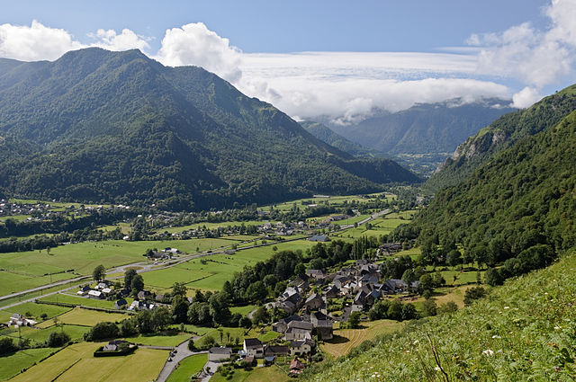
Français : La vallée d'Ossau vue des contreforts du Plaa de Soum. Sur la rive gauche
du gave d'Ossau, le bourg de Gère et le quartier Montplaisir de la commune de Gère-Bélesten ; sur la rive droite, une partie du village d'Aste-Béon (Pyrénées-Atlantiques, France).
English: The Ossau Valley in the French Pyrenees, seen from the foothills of the 'Plaa de Soum'. On the left bank of the 'gave d'Ossau', Gère and Monplaisir, neighborhoods of the commune of Gère-Bélesten; on the right bank, a part of the village of Aste-Béon. |
| Date | |
| Source | Own work |
| Author | Myrabella |
| Attribution (required by the licence) | Photo: Myrabella / Wikimedia Commons / |
| Camera location | | View this and other nearby images on: OpenStreetMap |
|---|
This image has been assessed using the Quality image guidelines and is considered a Quality image.
|
| Annotations | This image is annotated: View the annotations at Commons |
Licensing
I, the copyright holder of this work, hereby publish it under the following licences:
This file is licensed under the Creative Commons Attribution-Share Alike 3.0 Unported licence.
- You are free:
- to share – to copy, distribute and transmit the work
- to remix – to adapt the work
- Under the following conditions:
- attribution – You must give appropriate credit, provide a link to the licence, and indicate if changes were made. You may do so in any reasonable manner, but not in any way that suggests the licensor endorses you or your use.
- share alike – If you remix, transform, or build upon the material, you must distribute your contributions under the same or compatible licence as the original.

|
Permission is granted to copy, distribute and/or modify this document under the terms of the GNU Free Documentation Licence, Version 1.2 or any later version published by the Free Software Foundation; with no Invariant Sections, no Front-Cover Texts, and no Back-Cover Texts. A copy of the licence is included in the section entitled GNU Free Documentation Licence. |
You may select the licence of your choice.
File history
Click on a date/time to view the file as it appeared at that time.
| Date/Time | Thumbnail | Dimensions | User | Comment | |
|---|---|---|---|---|---|
| current | 01:08, 10 September 2010 | | 3,982 × 2,644 (6.66 MB) | Myrabella | == {{int:filedesc}} == {{Information |Description= {{fr|1=La vallée d'Ossau vue des contreforts du Plaa de Soum. Sur la rive gauche du gave d'Ossau, le bourg de Gère et le quartier Montplaisir de la commune de Gère-Bélesten ; s |
File usage
The following 2 pages link to this file: